Location: Weyerhauser Line, approx 2 mile east of Cameron.
Mile Post: 97.9
River / Creek: Rice Creek
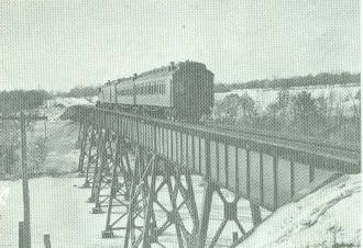
Structure Design: Steel Viaduct on Concrete Abutments and Footings.
Length: 566'
Height: Estimated over 100' in Center.
Status: Currently Out of Service, the line has been rail banked for future use.
Drawings / Plans: None available at this time.
General Description:
The bridge over Rice Creek is one of the largest on the Weyerhauser line, the only other large bridges are the St.
Croix drawbridge, the Pokegema river bridge west of Canton and the Chippewa River truss bridge, east of Bruce. The bridge
is 566' in length and over 100' high at the center.
The bridge was constructed as a steel viaduct type with a box girder on the top and steel towers supporting it.
It is unknown if this is the original bridge that was constructed when line building started in 1884, or if there was a wooden
brigde here that was replaced by the steel structure.
The bridge is now out of service with the CN sighting complaints that the structure has become unstable due to the
lack of maintenance since the WC take over in 1987. Crews also state that the abutments are in poor repair and that
crossing the bridge was a scary deal.
The photos were taken in the early 90's and the structure was pretty much the same as when the Soo Line owned it.
There were barrels along the side of the structure for fire control that were supported by small platforms. The
platforms rotted off and the barrels dropped into the creek below sometime in the mid 90's.
History:
Some history of the creek was found in a book named
"Barron, Polk & Burnett Counties", "
Excerpts
from Historical Writings". It is available from
A Plus Printing Company, Tucson, AZ.
"Rice Creek was originally named "Wild Rice Creek". It was named for the wild grain that grows in its shallow
sluggish water. Requiring neither sowing nor cultivation, wild rice was long an important Indian food, so important,
in fact, that many a warrior died in the constant warfare the Sioux and Chippewa waged for possession of the larger fields
in this region. Although the wars have ended now, swarthy Indians still gather the grain in the simple and laborious
way of thier ancestors."
Today, no there is no longer rice grown in Rice Creek. The waters are now polluted with agriculture runoff and
from late spring to late fall the waters are overgrown with thick green growth.
In the early spring, when the water is crystal clear, walleyes converge on this location to spawn in the slow shallow
waters and are easily seen from culverts under Hwy 8, in the shadow of the former Soo Line bridge.